- Recommended articles
- November 15, 2016
Toward the effective geodetic observation network
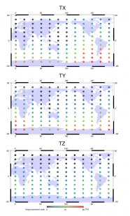
About 40 tracking stations all over the world are currently operational for Satellite Laser Ranging (SLR), a very precise geodetic technique. Otsubo et al. (2016) ran a unique simulation to find the optimal place of a future SLR station. The answer depends on a geodetic product and one example is shown for the center of gravity of the Earth: the X and Y components are largely improved by a high-latitude station especially in the southern hemisphere, whereas the Z component is improved by a low-latitude station.
![[Frontier Letter] Nonplanar 3D fault geometry controls the spatiotemporal distributions of slip and uplift: evidence from the Mw 7.5 2024 Noto Peninsula, Japan, Earthquake](https://www.earth-planets-space.org/wp-content/uploads/2025/03/40623_2025_2187_Figa_HTML-1-48x40.webp)
![[Frontier Letter] The theoretical basis for textural indices of eruption dynamics: review and new conceptual models](https://www.earth-planets-space.org/wp-content/uploads/2024/06/40623_2025_2146_Figa_HTML-66x40.png)